MEmob+ — AI-powered AdTech and location intelligence platform.
Login
  • EN
    • AR
  • EN
    • AR
  • Solutions

    Solutions

    Location Intelligence

    Use meaningful insights from people's mobility to improve your brand's marketing strategy.

    Market Research & Analysis

    Elevate your marketing strategy and ROAS with a unique blend of consumer insights, location intelligence, and online behavior.

    Targeting & Attribution

    Say goodbye to your challenges by crafting captivating tailored messaging and engage your audiences with a seamless experience.

    Data-Driven Creatives

    Make your first impression memorable. Your creative message is the first touchpoint with your target audience.

    Blockchain with MEmob+

    Step into the future of digital transformation with blockchain innovations and the Metaverse for a seamless transition from Web 2 to Web 3.

  • Products

    Products

    AllPings logo

    Precise Mobility Insights for Strategic Decision-Making

    Stretch logo

    Amplify Reach, Track & Measure Media Campaigns Impact

    Blueprint logo

    Data-Driven Dynamic Creative Studio

    Excelate logo

    Data & Al-powered DSP

  • Insights

    Insights

    Learning Hub

    Your guide to the shifting landscapes of audience, data, and location intelligence.

    Case Studies

    Real-world success stories, driven by audience insight and intelligent data.

    Unlock the secrets to success: visit our blog for fresh perspectives!

    Read More
  • Company

    Company

    About

    Leading Data Intelligence & Martech company pioneering blockchain integration in the MENA region.

    Awards

    We are an award-winning team committed towards innovation and excellence.

    Marketing Glossary

    Your guide to AI, location intelligence, consumer mobility, attribution and data-driven marketing concepts.

    Unlock the secrets to success: visit our blog for fresh perspectives!

    Read More
  • Get Free Consultation
  • EN
    • AR
  • EN
    • AR
Login
MEmob+ — AI-powered AdTech and location intelligence platform.

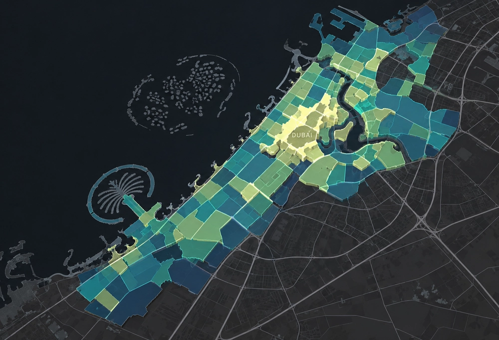
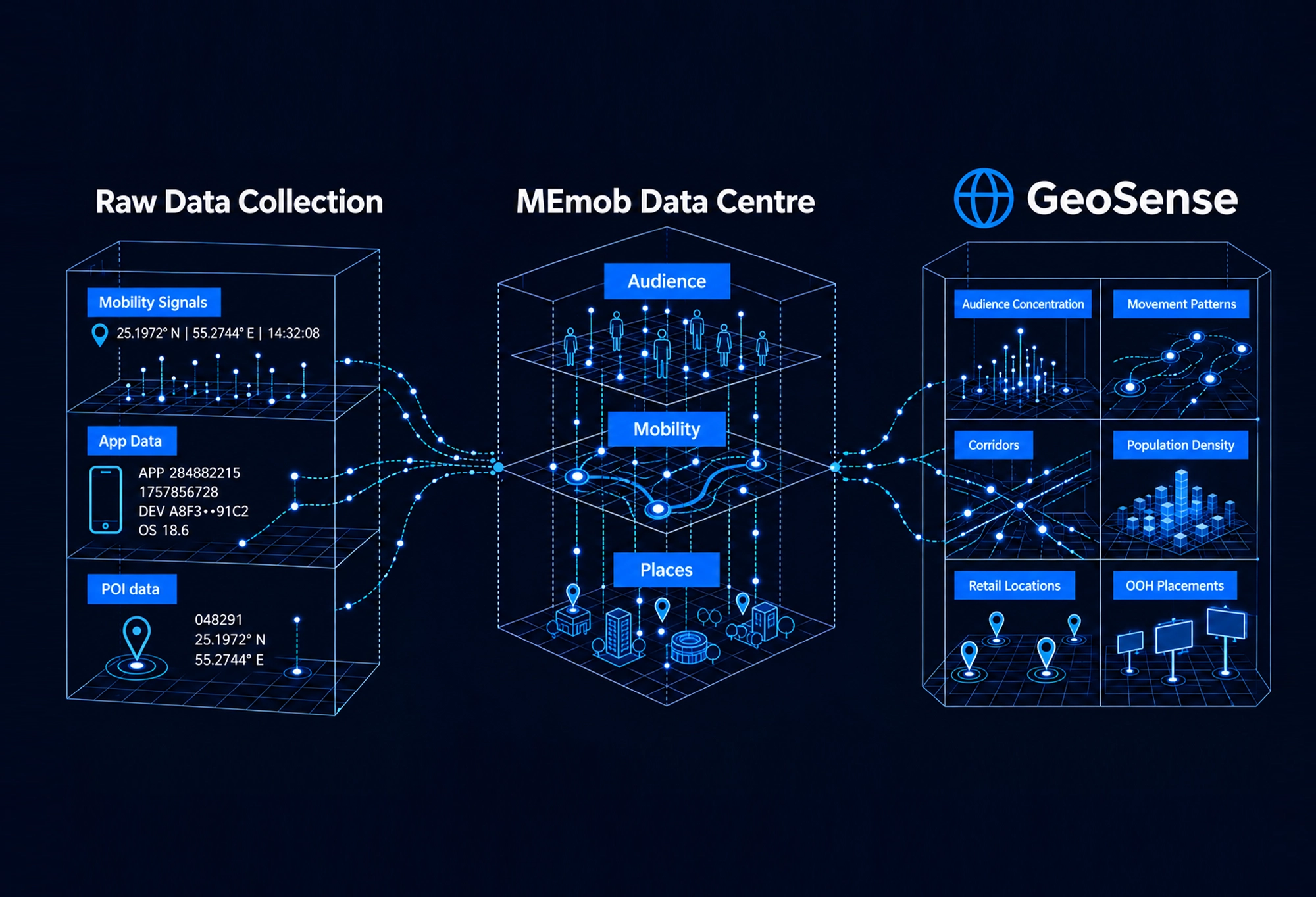
Geosense is MEmob’s proprietary geospatial visualization platform that transforms enriched location data into live, actionable geo-maps 

Book a Demo

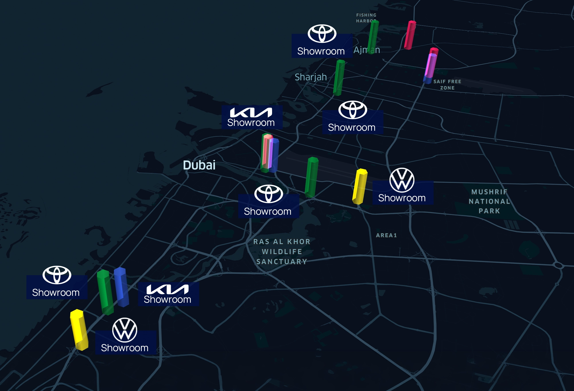
Through one browser-native dashboard, see exactly where your audience concentrates, plan out-of-home placements against real movement and prove the footfall impact your campaign  actually delivered.

SEE

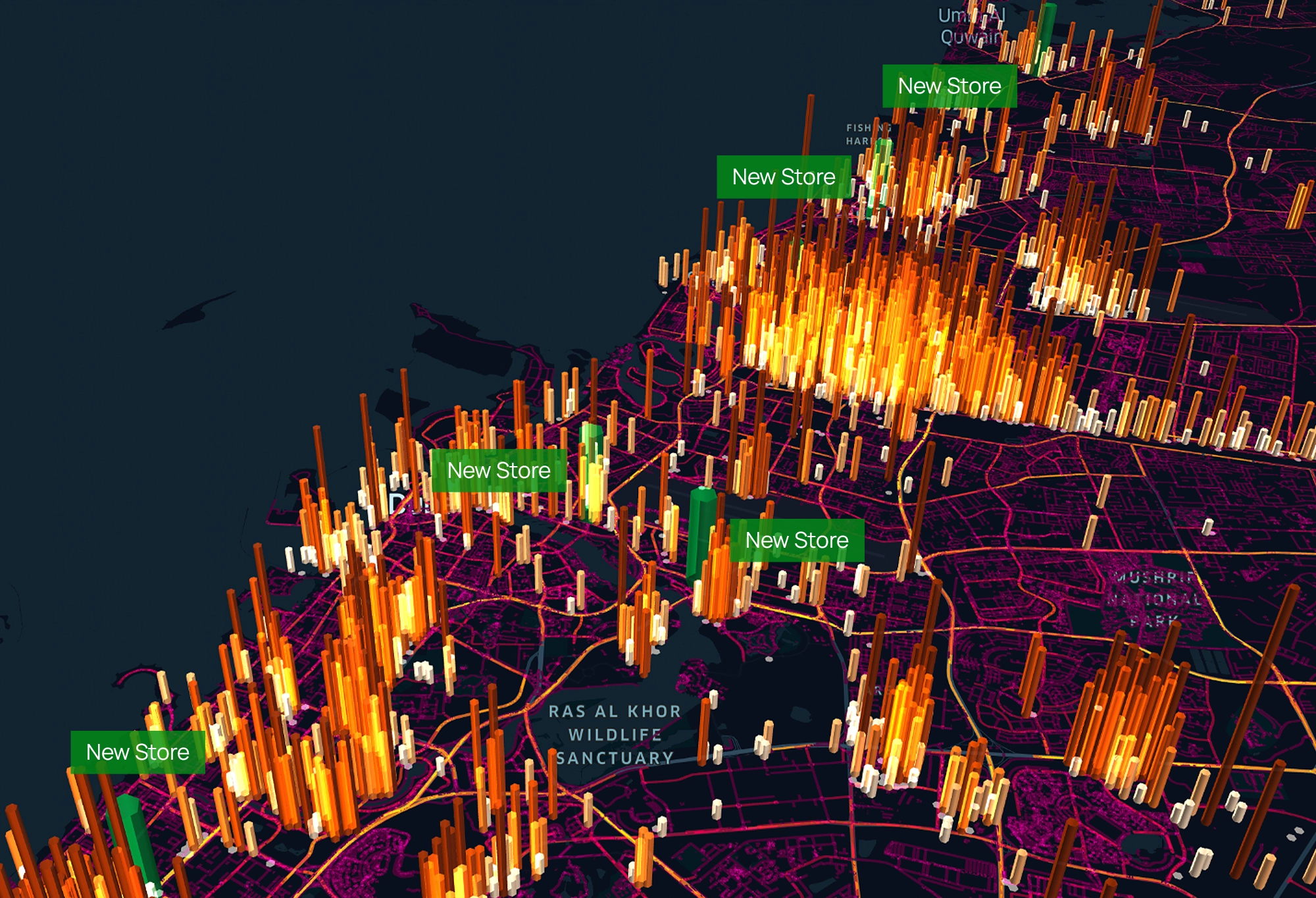
Audience density, dwell time, and movement across a city or country 

PLAN

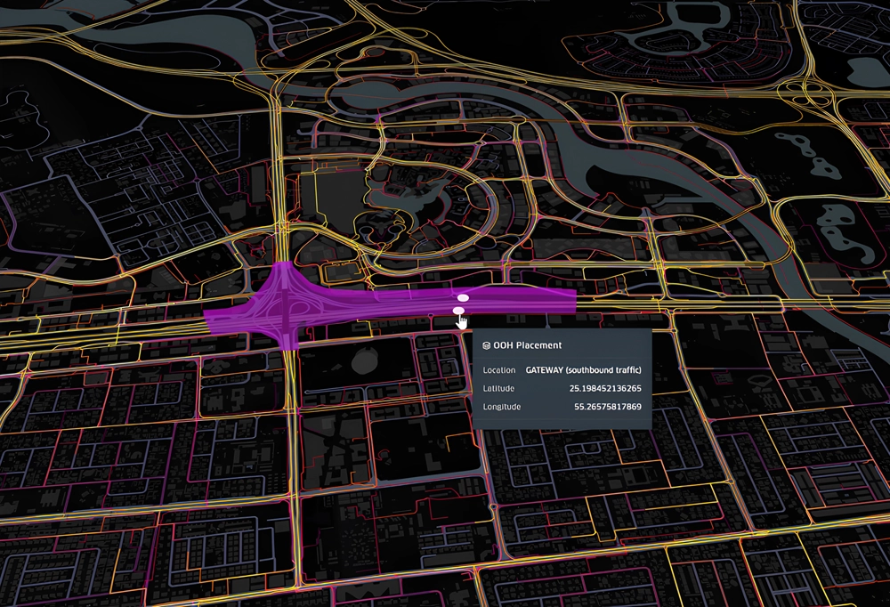
OOH & DOOH sites scored against real audience mobility

COMPARE

Your locations against competitors, catchments, and audience overlap

ENRICH

Your audiences with demographics, income, nationality, interests, affinity & more

MEASURE

Exposure-to-visit attribution and footfall lift, proven on the map

Understand how audiences move.
Map Real-World Movement.
Identify High-Impact Locations for your business.

Get a Free Demo Now!

Created by Geosense User Community

Audience + Mobility +
Market Intelligence Layers Connected

7 Reasons Why
Brands & Agencies Choose Geosense

1. Mobility Density & Dwell Time Mapping

See where audiences concentrate, when activity peaks, and which locations consistently attract attention.

2. Audience Concentration & Geo-Behavioral Clustering

Pinpoint the places your audience naturally gathers most and potentially overlaps.

3. Dynamic Catchment Modeling & Geofence Creation

Build areas of interest around how people actually move.

4. Location Affinity Scoring & Segment Comparison

Compare how different audiences behave across the same map.

5. Competitive Proximity Analysis

Identify where competitor presence is strongest  among your target audience. 

6. OOH/DOOH Exposure Zone Mapping

Identify high-potential placements based on where your audience moves, lives, works, and spends time.

7. Exposure-to-Visit Attribution & Incrementality Measurement

Prove an actual footfall lift by connecting Stretch Tag, isolating real lift vs. control group data. 

Geosense
Knowledge Center

Expert answers to the most important questions about  Geospatial Analytics, Consumer Mobility, Audience Intelligence, Geofencing & Planning of OOH Placements.

What is Geosense?

GeoSense is MEmob’s proprietary geospatial intelligence platform. It turns anonymised mobility data into live, interactive maps that show where a defined audience lives, works, and moves, how long they dwell in places of interest, and who they are once the data is enriched. It is a visualization and intelligence platform.

What questions can GeoSense answer?

GeoSense is built to answer questions such as:

  • Where does my target audience live, work, and spend time?
  • Who visits my stores and my competitors’ stores, and where do those audiences overlap?
  • Where should I open my next location, based on audience density in the catchment?
  • Where does a specific audience move, so I can plan OOH and DOOH against real behaviour?
  • Where are in-market tourists staying and going, and what are they doing?


How is GeoSense different from a standard mapping or GIS tool?

A GIS or mapping tool shows where things are. GeoSense shows who moves through a place, how often, how long they stay, and who they are. It is built as an audience and mobility intelligence layer, not a cartography tool. Two locations with identical foot traffic can look completely different in GeoSense, because the audiences moving through them are different.

What is the Geosense Intelligence Model?

The Geosense Intelligence Model is the three-layer analytical framework that turns raw movement into a market decision, and it’s the structure behind everything the platform visualizes.

Audience Intelligence: behavioural segments built from real-world visitation, affinity and frequency, answering who is actually being reached.

Mobility Intelligence: flow, dwell, daypart, catchment and movement patterns across the city, answering how and when audiences move.

Market Intelligence: competitor overlap, opportunity zones and location-level demand signals, answering where the commercial opportunity is strongest.

How does Geosense support OOH and DOOH media planning?

Geosense replaces radius-based OOH guesswork with spatial evidence by overlaying audience footfall heatmaps directly onto OOH site coordinates, so planners can see which placements sit inside genuinely high-density audience zones and which are wasted impressions before a single site is booked.

The workflow runs in four stages, matching how media and creative teams already work: Plan: load audience heatmaps against candidate OOH sites and buy from spatial evidence rather than assumption. Target: define geo-targeted digital and in-store proximity activation zones from the same behavioural data, so digital and physical planning use one audience definition. Measure: a post-campaign split-map comparison shows footfall before vs. after by zone and store; the map is the measurement, not a table a client has to interpret. Report:  live Geosense maps are embedded directly into campaign debrief documents, so clients interact with the data instead of reading it.

This is also where the platform’s time dimension matters most: hourly footfall animation identifies peak windows for staffing and campaign timing, day-of-week rhythm shows how Monday behaviour differs from Saturday, and seasonal trend playback animates a full year; useful for showing how tourism flows shift in high season or how retail density changes during Ramadan.

Who should use Geosense?

Geosense is built for any brand, agency or commercial team that needs a shared, visual answer to where audiences are, how they move, and whether media investment changed that behaviour most directly, OOH and DOOH planners, media and advertising agencies, and brand/commercial teams running location-based or omnichannel campaigns across MENA.

For media and advertising agencies, Geosense turns audience discovery and OOH planning into a spatial, client-facing deliverable rather than a spreadsheet; the same map used to plan the buy becomes the map used in the debrief. For brand and commercial teams, it gives marketing, retail and expansion functions a common view of audience quality, physical context and commercial outcome, so budget conversations run on visible evidence rather than assumption. For retailers, tourism boards, automotive and other location-dependent industries already using AllPings for audience intelligence, Geosense is the natural next layer it makes those audiences visible in space and, connected to Stretch, provable in outcome.

How is Geosense different from traditional OOH ratings and traffic-count data?

Traffic counts estimate how many people pass a location; Geosense identifies who those people are, whether they match a target audience, and whether exposure changed their behaviour. Two sites with identical traffic can score very differently in Geosense depending on which audience segments actually move through each one. It also closes the measurement gap traffic counts leave open measuring actual exposure-to-visit attribution and lift, not just potential reach.

Does GeoSense measure campaign performance?

GeoSense is an intelligence and visualization platform. Campaign attribution, cross-channel measurement, and incremental lift are handled by Stretch, MEmob’s measurement product. GeoSense shows you the audience and the market; Stretch proves campaign impact.

Is Geosense privacy-compliant?

Yes. Geosense uses aggregated, anonymised mobility signals, the same privacy-first foundation as AllPings and supports compliance with GDPR, CCPA, and PDPL. No personally identifiable information is exposed during audience mapping, catchment modeling, or attribution.

Can I activate the audiences I see in GeoSense?

Yes. Audiences identified in GeoSense can be activated through AllPings, MEmob’s audience activation platform. Activation requires an AllPings subscription. GeoSense is the intelligence and visualization layer; activation happens in AllPings.

What do I need to provide to get started?

To build a GeoSense view, you provide the audience you want to understand or the locations of interest, for example your stores, competitor sites, or a list of OOH placements. MEmob handles the rest.

How do I receive GeoSense outputs?

GeoSense is delivered as a live, interactive dashboard. Views can be captured directly from the platform for use in presentations, reports, and client debriefs.

Comparison of Geospatial Intelligence, GIS and Location Intelligence by MEmob
Data-Driven Insights
Lucie Blahova

Geospatial Intelligence vs GIS vs Location Intelligence: A three Way Comparison

By: Lucie Blahova Marketing Lead MEmob Published: August 11th 2026   These three terms get used interchangeably, but they sit at different layers of the

Read More »
August 11, 2026 No Comments
Illustration showcasing 12 location intelligence use cases including competitor conquesting, site selection, location-aware creatives, OOH optimization, and retail marketing applications.
MarTech Strategies
Lucie Blahova

12 Location Intelligence Examples & Applications 2026

By: Lucie Blahova Marketing Lead MEmob Published: July 22nd 2026 Location intelligence sounds abstract until you see it applied. In practice, it means concrete plays:

Read More »
July 22, 2026 No Comments
Illustration comparing geospatial intelligence and location intelligence, showing satellite imagery, mapping, consumer movement, and behavioral insights.
Data-Driven Insights
Lucie Blahova

Geospatial Intelligence vs Location Intelligence: What’s the Difference?

By Lucie Blahova Marketing Lead, MEmob Published: July 13th 2026 LinkedIn: Lucie Blahova   Geospatial intelligence and location intelligence are often used interchangeably; but they

Read More »
July 13, 2026 No Comments

Data quality insights and best practices delivered to your inbox every month.

Solutions

  • Location Intelligence
  • Market Research & Analysis
  • Targeting & Attribution
  • Data-Driven Creatives
  • Blockchain with MEmob+
  • Location Intelligence
  • Market Research & Analysis
  • Targeting & Attribution
  • Data-Driven Creatives
  • Blockchain with MEmob+

Products

  • AllPings
  • Stretch
  • Excelate
  • Blueprint
  • AllPings
  • Stretch
  • Excelate
  • Blueprint

Insights

  • Blog
  • Case Studies
  • Blog
  • Case Studies

Company

  • About Us
  • Awards
  • Marketing Glossary
  • Contact
  • About Us
  • Awards
  • Marketing Glossary
  • Contact

Legal

  • Terms of Service
  • Privacy Policy
  • End User Privacy Policy
  • Cookie Policy
  • Terms of Service
  • Privacy Policy
  • End User Privacy Policy
  • Cookie Policy

© 2026 MEmob+. All rights reserved.

Linkedin Instagram X-twitter Facebook Youtube

Book A Demo

Explore Endless Opportunities with MEmob+

BOOK A DEMO

Product Login

Select a product you desire to login to
AllPings by MEmob+ recognized for innovation in location intelligence and audience targeting across the GCC
Require access?
Contact Sales
  • Solutions
    • Location Intelligence
    • Market Research & Analysis
    • Targeting & Attribution
    • Data-Driven Creatives
    • Blockchain Technology
  • Products
    • AllPings
    • Excelate
    • Stretch
    • Blueprint
  • Resources
    • Learning Hub
    • Success Stories
  • Company
    • Awards
    • About
    • Marketing Glossary
Contact Us